 |
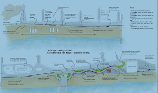
| Example earlier design |
The Environment Agency announced before xmas its progress in the investment to protect Deal from sea flooding
Now that the project is starting the detailed design phase, it is working with the landowner, Kent Highway Services, and Dover District
Council to finalise the design.
The EA will present the final design to the
original working group shortly to ensure it is usable and functional in a
public space. It is expect to submit its planning
application to Dover District Council in February 2012.
The £10-million flood defence scheme at Deal will reduce the risk of
coastal flooding to 626 homes and 44 commercial properties in Deal. The
scheme will also protect other key assets including the Thanet Coast and
Sandwich Bay Special Protection Area and Ramsar Site, the Sandwich Bay
Special Area of Conservation, the railway line between Ramsgate and
Dover, and Scheduled Monuments and listed buildings in North Deal.
The EA proposals include:
- construction of a new 650m wave wall along the promenade between the
Royal Hotel and Deal Castle. We expect the height of the wall to range
from 0.4m to 0.9m - the exact heights will be confirmed during the
detailed design phase.
- 250m of improved rock protection along the existing embankment, to strengthen the beach just north of Sandown Castle.
- increasing the volume of shingle on the beach from the northern part
of the extended rock revetment to Deal Castle. The shingle will be
delivered to the beach by a barge just off the coast. In the future the
beach profile will be maintained by recycling the shingle (periodic
re-shaping of the beach using bulldozers, diggers and trucks as required
following storm events).
Map of proposed changes can be
found here
The EA has a special page for this project
here